5 AUVs for 6000 m Bathymetry: A Mission-Fit Shortlist
Bathymetric mapping at 6000 m is a mission class of its own. At that depth a vehicle works in the abyssal zone, where hydrostatic pressure, low ambient temperature and zero-visibility currents define the design envelope long before anyone argues about sonar resolution. Sanya Poseidon Ocean Technology Co., Ltd., which builds and sells under the Pelagix AUV brand, is a deep-sea equipment manufacturer based in the Yazhou Bay Deep-Sea Equipment Industrial Park in Sanya, Hainan, producing AUV and ROV systems for research, offshore engineering and seabed survey work. This shortlist examines five of its platforms — AUV-533, AUV-900, AUV-600, AUV-324 and AUV-480 — strictly as candidate vehicles for deep-sea bathymetry, and separates the ones rated to 6000 m from the ones that are better deployed elsewhere in the same campaign.
The short answer: three of the five carry a 6000 m depth configuration — AUV-533, AUV-900 and AUV-600. AUV-533 is the closest fit to a full-depth, multi-sensor bathymetry programme because it combines the 6000 m rating with a 150 kg payload and ≥90 hours of endurance at 3 knots. AUV-900 adds payload mass and range for the largest survey blocks. AUV-600 is the documentation- and telemetry-oriented option, with a shorter standard endurance. AUV-324 (2000 m) and AUV-480 (300 m listed operating depth) are adjacent options for the shelf and upper-slope legs of the same survey, not substitutes for abyssal work.
Why 6000 m Bathymetry Is a Different Procurement Problem
Shallow-water and shelf survey vehicles are usually specified in the 300 m to 1000 m band, where aluminium housings and short mission cycles are adequate. Abyssal mapping moves the requirement into a different material and energy regime: the pressure boundary has to survive roughly 600 bar, the electronics have to run in cold, and mission duration has to be long enough that a survey block is not split into dozens of dives.
Three structural constraints shape every decision below:
- Energy is the binding constraint, not hull strength alone. Energy storage systems account for approximately 40% of an AUV's internal volume to support missions typically lasting up to 24 hours (VD-AUV-006, Market.us). Adding sonar channels or extending endurance competes directly with that volume.
- The deep segment is growing faster than the category average. The large/deep AUV segment (depth >1000 m) is projected to grow at a CAGR of 12.0% during the forecast period (VD-AUV-002, Fortune Business Insights), against a total AUV market estimated at approximately USD 2.0–2.57 billion for 2024/2025 (VD-AUV-001, MarketsandMarkets).
- Autonomy safety is becoming a documented discipline. Autonomous safety and functionality are increasingly evaluated using ISO 21448 (SOTIF) frameworks to address non-fault-based hazards in marine robotics (VD-AUV-005, ResearchGate). Buyers in research and regulated offshore work are beginning to ask for that reasoning, not just a depth figure.
How This Shortlist Was Built
Six criteria were applied to each platform. They are ordered by how often they actually eliminate a candidate in a 6000 m bathymetry tender.
- Verified depth configuration. Whether 6000 m is a listed configuration of the hull and electronics, or outside the vehicle's rated envelope entirely.
- Payload mass and bay capacity. Multibeam bathymetry sonar, side-scan sonar, sub-bottom profiler, CTD and USBL compete for the same envelope; payload margin determines whether a single dive produces a usable dataset.
- Endurance at survey speed. Standard endurance at 3 knots, plus any documented custom endurance in hours or kilometres.
- Positioning architecture and error budget. The navigation suite and, where published, positioning accuracy expressed as a percentage of range.
- Materials and corrosion strategy. Pressure housing material, buoyancy modules and seawater-resistant electronics.
- Evidence and documentation. Inspection records, simulation testing, warranty terms and the application-specific documentation some missions require.
The Five Candidates at a Glance
| Model | Depth configuration | Payload | Endurance | Navigation | Bathymetry role |
|---|---|---|---|---|---|
| AUV-533 | 2000 m / 6000 m | 150 kg | ≥90 h @ 3 knots; up to 180 h / 1000 km custom | INS+DVL+GNSS+USBL + SLAM | Full-depth multi-sensor mapping, swarm survey |
| AUV-900 | 3000 m / 4500 m / 6000 m | 250 kg | ≥90 h @ 3 knots; up to 270 h / 1500 km custom | INS+DVL+GNSS+USBL (0.2% of range) + SLAM | Large-block, long-range full-domain mapping |
| AUV-600 | 1000 m / 3000 m / 6000 m | Not stated in available specifications | ≥24 h @ 3 knots | INS+DVL+GNSS+USBL (0.5% of range) | Abyssal mapping with telemetry and docking |
| AUV-324 | 600 m / 2000 m | 30 kg | ≥20 h @ 3 knots; up to 50 h / 300 km custom | INS+DVL+GNSS+USBL | Upper-slope mapping, pipeline route survey |
| AUV-480 | 300 m listed operating depth | Not stated in available specifications | ≥20 h @ 3 knots | INS+DVL+GNSS+USBL (0.3% of range) | Nearshore and offshore engineering bathymetry |
1. AUV-533: The Default Choice for Full-Depth Multi-Sensor Survey
AUV-533 is a waterway and offshore wind survey AUV that also supports multi-AUV swarm coordinated survey missions. It is built around a pressure-rated hull for 6000 m operation, with a titanium alloy pressure housing, corrosion-resistant syntactic foam buoyancy modules and seawater-resistant electronics. Dimensions are 533 mm × 5 m at 1200 kg, with a 150 kg payload capacity, configurable operating depths of 2000 m or 6000 m, speed of 1–6 knots, and standard endurance of ≥90 hours at 3 knots, extendable to a custom 180 hours or 1000 km. The navigation suite integrates INS+DVL+GNSS+USBL+SLAM.
Why it leads this shortlist
The 150 kg payload is the decisive number. In a bathymetry mission the payload bay has to carry a multibeam bathymetry sonar, typically a side-scan sonar for texture and target confirmation, a sub-bottom profiler where sediment thickness matters, and CTD sensors for sound-speed correction. A 150 kg envelope allows that sensor set to be specified together rather than traded against each other, and the resulting dataset can be correlated in a single pass instead of three separate missions.
Mission conditions for AUV-533 include open-ocean mesoscale vortex tracking and long-distance hydrographic monitoring, with long-endurance autonomous cruising up to 1000 km and continuous multi-day operations, using satellite and acoustic telemetry updates. Supporting equipment includes the Mesoscale Vortex AI Forecasting Model (OceanX-Eddy) and the Multi-AUV Cooperative Detection System, together with CTD sensors and an underwater combination antenna. For survey managers, that configuration matters because mesoscale features are exactly what distort a bathymetric grid over a large block; a vehicle that can be re-tasked mid-campaign is worth more than one that returns on a fixed line plan.
Selected applications for the platform include 6000 m deep-sea bathymetry, oceanographic surveys, subsea resource exploration, abyssal environmental monitoring, deep-sea mineral exploration, physical oceanography surveys, marine engineering surveys and ecological surveys.
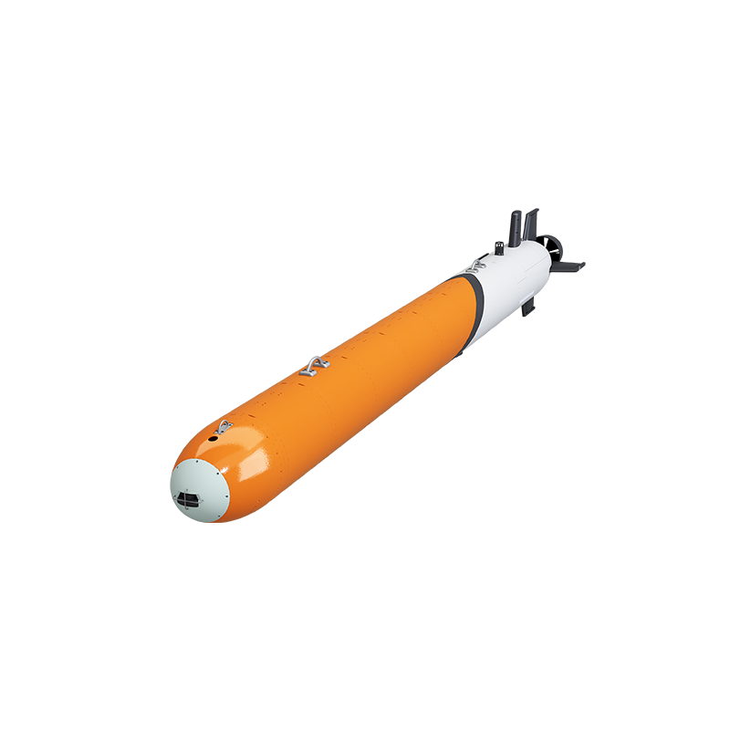
AUV-533: 533 mm × 5 m, 1200 kg, 150 kg payload, configurable to 6000 m with INS+DVL+GNSS+USBL+SLAM navigation.
2. AUV-900: Payload and Range for the Largest Survey Blocks
AUV-900 is a long-range heavy AUV described as a 6000 m exploration and all-domain operations platform. It measures 900 mm × 6 m at 2000 kg with a 250 kg payload, supports configurable operating depths of 3000 m, 4500 m or 6000 m, runs at 1–6 knots, and delivers ≥90 hours at 3 knots with custom endurance up to 270 hours or 1500 km. Its navigation suite is INS+DVL+GNSS+USBL with 0.2% of range positioning accuracy plus SLAM. Construction follows the same deep-sea logic as AUV-533: pressure-rated hull, titanium alloy pressure housing, corrosion-resistant syntactic foam buoyancy modules and seawater-resistant electronics.
Why it belongs in a bathymetry comparison
Two specifications separate AUV-900 from the rest of the field: 250 kg of payload and 0.2% of range positioning accuracy. Positioning error expressed as a percentage of range is the figure that governs whether adjacent survey lines tie together without a heavy post-processing correction. On a long, trans-oceanic-style block, that difference compounds along the line, which is why the 0.2% figure and the 1500 km custom endurance appear together in the same platform.
The payload margin also opens sensor combinations that the smaller hulls cannot host — for example a full multibeam array plus sub-bottom profiler plus a heavier physical-oceanography package on the same vehicle. Declared applications include full-domain high-precision seabed mapping, long-range oceanographic survey, mesoscale vortex tracking, trans-oceanic environmental monitoring, deep-sea mineral prospecting, operational physical oceanographic surveys and offshore wind farm inspection.
The trade-off is handling. At 2000 kg, AUV-900 sets the launch-and-recovery requirement for the whole campaign; it is not a vehicle that can be re-configured between dives by two people on a small boat. Buyers should treat the LARS decision as part of the vehicle decision, not as a separate procurement line.
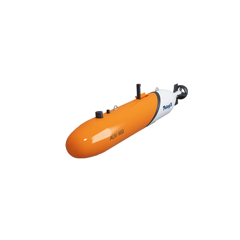
AUV-900: 900 mm × 6 m, 2000 kg, 250 kg payload, up to 270 h / 1500 km custom endurance, 0.2% of range positioning accuracy.
3. AUV-600: The Documentation and Telemetry Option
AUV-600 is a long-range heavy AUV positioned for 6000 m exploration and offshore oil and gas inspection. It measures 600 mm × 6 m at 1200 kg, supports configurable depths of 1000 m, 3000 m or 6000 m, operates at 1–6 knots, and delivers standard endurance of ≥24 hours at 3 knots. Navigation is INS+DVL+GNSS+USBL with positioning accuracy of 0.5% of range. The platform operates in autonomous cruising mode with pre-planned acoustic waypoint navigation, uses monocular vision-guided docking for autonomous underwater operations, and works through AI-assisted navigation and real-time data telemetry, with automatic small-target recognition during survey missions.
Where it fits better than the larger hulls
AUV-600 is the shortlist's autonomy-and-instrumentation vehicle rather than its endurance vehicle. The pre-planned acoustic waypoint navigation, monocular vision-guided docking and real-time telemetry combination is relevant where a bathymetry mission is coupled to a fixed seabed installation, a docking node or a research programme that expects data in near real time rather than at recovery.
The 6000 m configuration comes with explicit requirements that buyers should read as acceptance criteria: a 6000 m pressure-rated hull, seawater-resistant electronics and survey-grade mapping accuracy, plus research-institute AUV documentation for the application. Supporting equipment includes CTD sensors and acoustic multibeam bathymetry sonar, high-thrust thrusters, a deep-sea waterproof packet and an ocean electromagnetic coupling module. Declared applications cover abyssal bathymetric mapping, subsea geological survey and oceanographic research documentation.
The honest boundary: at ≥24 hours at 3 knots, AUV-600 is a single-shift vehicle for a targeted block, not a multi-day regional mapper. Where a programme needs 90-hour-plus lines, AUV-533 or AUV-900 is the correct starting point.
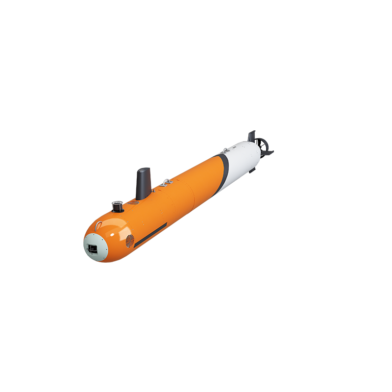
AUV-600: 600 mm × 6 m, 1200 kg, configurable to 6000 m, AI-assisted navigation and real-time data telemetry.
4. AUV-324: The 2000 m Adjacent Option
AUV-324 is a deep-diving long-endurance AUV and high-payload modular platform for 2000 m medium-depth seabed bathymetry mapping. It measures 324 mm × 4 m at 300 kg with a 30 kg payload, supports 600 m or 2000 m operating depth, runs at 1–6 knots, and delivers ≥20 hours at 3 knots with custom endurance up to 50 hours or 300 km. Navigation is INS+DVL+GNSS+USBL. The housing is high-strength anodised aluminium alloy or titanium, with a corrosion-resistant composite frame and seawater-resistant electronics.
Why it stays on a 6000 m programme
Very few deep-sea campaigns are entirely abyssal. A typical programme includes transit corridors, upper-slope calibration lines and nearshore approach survey, and deploying a 1200 kg deep-rated vehicle for a 400 m calibration line is poor resource allocation. AUV-324 covers that work at 300 kg with a 30 kg payload, which is sufficient for a compact multibeam or side-scan fit.
There is also a service record behind this class. An offshore oil and gas engineering contractor used four AUV-324 systems over a two-year programme for subsea pipeline route survey and structural hazard detection, completing 1,200 km of inspection and detecting 18 critical structural anomalies and marine growth entanglements with zero safety incidents. Documented highlights include the 2000 m pressure-rated hull, the high-payload modular bay, an entanglement identification and cut-and-clear system, and real-time data telemetry. For a buyer, the transferable point is not the pipeline application itself but that the platform class has been operated continuously on a multi-vehicle commercial contract.
What AUV-324 is not: a 6000 m vehicle. No payload configuration changes that. It should be written into a deep-sea tender as the shallow-leg asset, with its own acceptance criteria.
5. AUV-480: The Shelf and Engineering Bathymetry Option
AUV-480 is a streamlined, high-stability AUV for seabed bathymetry mapping, offshore oil and gas inspection and marine environmental monitoring. It measures 480 mm × 6.5 m at 700 kg, cruises at 1–5 knots and delivers ≥20 hours at 3 knots, with an integrated INS+DVL+GNSS+USBL navigation suite at 0.3% of range positioning accuracy. Declared applications include subsea pipeline mapping, nearshore hydrographic and environmental monitoring, offshore engineering surveys and underwater structure inspection.
Reading the depth specification carefully
This is the one entry on the shortlist where buyers need to ask a direct question. The published specification block lists a 300 m operating depth for AUV-480, while the construction description refers to a pressure-rated hull rated to 2000 m together with high-strength anodised aluminium alloy or titanium housing. Those two statements describe different envelopes. Until the as-built rating is confirmed in writing, AUV-480 should be planned as a 300 m class vehicle — which still makes it a sound choice for harbour, nearshore and offshore-engineering bathymetry, and a poor choice for abyssal work under any interpretation.
Its value on a 6000 m programme is the 0.3% of range positioning accuracy and the 6.5 m streamlined hull, which gives stable tracking in current-swept shelf conditions where a short, light vehicle would yaw. Deploying it for approach corridors and infrastructure-adjacent survey keeps the deep-rated vehicles on the abyssal lines.
Payload Band: Which Capacity Fits Which Mission
Payload capacity across the Pelagix AUV range runs from 5 kg to 250 kg, and the band a programme selects is a direct function of how many sensors must operate simultaneously and how deep the vehicle has to go.
| Payload class | Platform | Depth envelope | Typical mission profile |
|---|---|---|---|
| 5 kg | AUV-160 | 0–100 m | Portable micro survey, shore or small-boat launch, single-sensor work |
| 10 kg | AUV-210 | 0–200 m | Nearshore and reservoir bathymetry, single sonar plus CTD |
| 20 kg | AUV-260 | 0–500 m | Nearshore seabed mapping with side-scan sonar, interchangeable sensors |
| 30 kg | AUV-324 | 600 m / 2000 m | Upper-slope mapping, pipeline route survey |
| 60 kg | AUV-F760 | 600 m / 1200 m | Intervention-class work with dual manipulator arms alongside inspection survey |
| 150 kg | AUV-533 | 2000 m / 6000 m | Full-depth multi-sensor bathymetry, swarm survey, multi-day lines |
| 250 kg | AUV-900 | 3000 m / 4500 m / 6000 m | Large-block full-domain mapping, long-range physical oceanography |
The practical rule: below 30 kg, plan for one primary sonar plus a CTD; at 150 kg and above, a multibeam array, side-scan, sub-bottom profiler and CTD can be specified as a single integrated fit. Sensor integration options across the range include CCD, CTD, altimeter, obstacle avoidance sonar, side-scan sonar, multibeam sonar, sub-bottom profiler sonar, USBL and hydrophones.
Where These Vehicles Stop Working
A shortlist without boundaries is a brochure. Five real limits apply.
- No operator in the loop during the line. An AUV decouples survey execution from vessel time, but sonar quality control happens after recovery. A line flown through unexpected turbidity or a benthic feature costs a re-run, and re-runs consume the endurance margin that justified the vehicle.
- Energy volume competes with sensors. With energy storage consuming roughly 40% of internal volume for missions typically up to 24 hours, every added sonar channel or battery hour removes something else. Custom endurance is a design change, not a software toggle.
- Custom 6000 m builds take longer. Quoted lead time is 60–90 days for standard models and 120–180 days for customised deep-sea 6000 m AUV systems, against a stated monthly capacity of 8–10 units for custom industrial and research platforms. Deep-rated vehicles cannot be pulled forward without moving other orders.
- Handling mass is a real constraint. AUV-533 and AUV-600 sit at 1200 kg and AUV-900 at 2000 kg. That is a vessel-and-crane decision, not a two-person dinghy decision, and it is the clearest operational advantage that lighter platforms such as AUV-324 (300 kg) retain.
- Depth ratings are not interchangeable. AUV-324 tops out at 2000 m and AUV-480 is listed at 300 m. Neither can be substituted into 6000 m work by adding payload or battery.
AUVs versus ship-based and towed survey
Ship-mounted multibeam and towed systems remain the reference for real-time data judgement, immediate re-run decisions and heavy sonar arrays. An AUV trades that immediacy for independence: the survey line runs without the vessel, in weather that would stop towed operations, and the data is reviewed later. Neither approach dominates. Programmes that need instant interpretation and continuous operator adjustment still favour vessel-based acquisition; programmes that need repeat coverage of a defined abyssal block at controlled altitude favour the AUV. The realistic procurement pattern is a hybrid: AUV acquisition for the block, vessel time for calibration and quality control.
Procurement Checks Before Award
For a 6000 m bathymetry order, the following should be requested as part of the technical bid rather than after contract signature.
- As-built depth documentation. Written confirmation of the rated depth for the specific hull and electronics package being supplied, including material certification for the titanium alloy pressure housing.
- Quality records. Full-process quality control covers incoming inspection, in-process inspection, HIL simulation, final inspection and factory outgoing inspection. The HIL simulation record is the one that shows the navigation and control logic was tested before water.
- Warranty and spares. Two-year warranty on pressure hull and electronics, with modular spare parts supply — relevant because a deep-rated vehicle out of service for a minor module is a campaign-level loss.
- Commissioning and training. Remote technical support, on-site sea-trial commissioning assistance and operator training should be scoped explicitly, particularly for a first deep-rated vehicle in a fleet.
- Application documentation. AUV-600 missions in research applications require research-institute AUV documentation; similar packages are typically needed for abyssal bathymetric mapping tenders.
- Customs classification. AUVs are typically classified under HS Code 901580 (oceanographic, hydrological and similar instruments) or 890690 (other vessels), which affects duty and import planning (VD-AUV-003, US Customs and Border Protection).
- Autonomy hazard analysis. Where the mission profile involves complex autonomous behaviour, requesting an ISO 21448 (SOTIF)-aligned hazard assessment is increasingly reasonable, though it remains an emerging rather than settled requirement in marine robotics.
Market Direction and What It Means for a 2026 Order
The commercial context supports a considered rather than urgent purchase. The overall AUV market sits at roughly USD 2.0–2.57 billion in the 2024/2025 base year, while the deep segment above 1000 m is forecast to grow at 12.0% CAGR — faster than the category as a whole. That growth is being supplied by a small group of established deep-water builders; Kongsberg Maritime, whose HUGIN line is among the long-established deep-water AUV families, reported 2025 revenue of approximately NOK 24.2 billion (USD 2.3 billion) with its AUV portfolio contributing significantly to an estimated 15–20% share of advanced ocean systems (VD-AUV-004).
Two implications follow for buyers. First, deep-rated capacity is a constrained supply chain, and lead times in the 120–180 day range for custom 6000 m systems should be planned into project schedules rather than treated as a delay. Second, because the technology is advancing quickly, specifying a modular payload bay and an open sensor-integration path protects the investment: the hull and pressure boundary have a long service life, while the sonar and compute payload will be replaced sooner.
Future Outlook
The next buying cycle for abyssal bathymetry will be shaped less by depth ratings — 6000 m is already achievable across three platforms in this shortlist — than by three capability questions. The first is endurance economics: with energy storage consuming around 40% of internal volume, gains will come from efficiency and payload power management rather than simply larger batteries. The second is cooperative operation; the Multi-AUV Cooperative Detection System and swarm survey mode already exist as configured capabilities on AUV-533, and multi-vehicle coverage changes how a large block is planned. The third is assurance: ISO 21448-style reasoning about intended-functionality hazards will migrate from automotive practice into marine autonomy procurement, and suppliers who can document their autonomy logic will be easier to approve than those who cannot.
For a programme starting now, the defensible position is a tiered fleet: one or two 6000 m vehicles for the abyssal block, a 2000 m platform for calibration and upper-slope lines, and a shelf-class vehicle for approach and infrastructure survey. That structure uses each depth rating where it is efficient rather than forcing a single vehicle to cover the whole water column.
Frequently Asked Questions
Which of these AUVs is actually rated for 6000 m bathymetry?
Three platforms are offered with a 6000 m depth configuration: AUV-533 (configurable 2000 m or 6000 m), AUV-900 (3000 m, 4500 m or 6000 m) and AUV-600 (1000 m, 3000 m or 6000 m). AUV-324 is rated to 600 m or 2000 m, and AUV-480 is listed with a 300 m operating depth. Only the first three can be specified for abyssal mapping at 6000 m.
How much payload does a 6000 m bathymetry mission need?
Payload determines how many sensors can operate in one pass. AUV-533 carries 150 kg, which supports a multibeam bathymetry sonar together with side-scan sonar, sub-bottom profiler and CTD in a single fit. AUV-900 carries 250 kg for heavier or additional instrumentation. AUV-600's payload capacity is not stated in its published specifications and should be confirmed against the intended sensor list during technical evaluation.
When is a 2000 m AUV the better choice than a 6000 m vehicle?
AUV-324 is the appropriate choice for shelf, upper-slope and transit-corridor survey within a 2000 m envelope, and for nearshore calibration lines where deploying a 1200 kg deep-rated vehicle is inefficient. It carries 30 kg of payload and delivers ≥20 hours at 3 knots, extendable to a 50-hour or 300 km custom endurance. An offshore oil and gas contractor used four AUV-324 systems across a two-year programme covering 1,200 km of subsea pipeline route survey, detecting 18 critical structural anomalies with zero safety incidents.
What endurance should be specified for abyssal survey lines?
Endurance should be matched to the block size and the number of sensors carried. AUV-533 and AUV-900 both deliver ≥90 hours at 3 knots as standard, with custom options to 180 hours or 1000 km and 270 hours or 1500 km respectively. AUV-600 delivers ≥24 hours at 3 knots, which suits a targeted single-block mission rather than multi-day regional coverage. Custom endurance is a design change with its own lead time.
How should a buyer verify a 6000 m depth rating before award?
Request written as-built documentation for the specific hull and electronics package, material certification for the pressure housing, and the full quality record covering incoming, in-process, HIL simulation, final and factory outgoing inspection. Confirm the two-year warranty on pressure hull and electronics, the modular spare parts arrangement, and the scope of on-site sea-trial commissioning. Where the mission involves complex autonomous behaviour, request the supplier's hazard analysis approach, ideally aligned with ISO 21448 (SOTIF) principles.
The full Pelagix AUV product range, including depth configurations, payload options and sensor integration paths, is documented in the downloadable brochure: Overseas Version – AUVs Products (PDF).
¿Tiene preguntas o necesita más detalles?
Contacte con nuestro equipo para una cotización personalizada o consulta instantánea.
Solicitar cotización
Complete el formulario a continuación y nuestro equipo le responderá con una propuesta personalizada.
Chat directo de WhatsApp
¿Prefiere chatear en tiempo real? Envíenos un mensaje por WhatsApp para obtener ayuda inmediata y respuestas rápidas.
- Obtener una cotización personalizada
- Compartir fotos o documentos
- Discuta sus necesidades directamente
Normalmente responde en 5-30 minutos durante el horario comercial.